
The stone could have been used as a star clock to track seasonal changes.
The artifact, which shows several constellations, dates back to the late Neolithic to the early Iron Age.
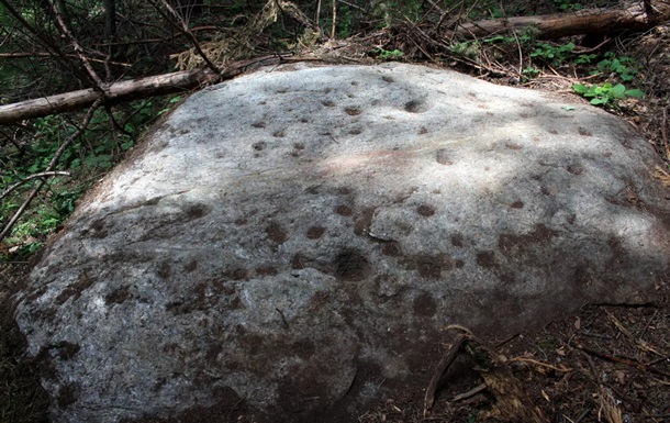
In the Rhodope Mountains in southern Bulgaria, archaeologists have discovered a unique artifact – a stone with a carved map of the starry sky, which is likely one of the oldest known attempts to depict the night sky in stone. This was reported by Arkeonews, to which researcher Georgi Georgiev personally sent a statement about the find.
The stone, measuring approximately 2×3 meters, lies in a forest near a Thracian necropolis. Its surface has 56 conical depressions of different diameters – 24 in the northern part and 32 in the southern – which probably symbolize stars of different brightness. The images on the stone allow us to recognize several constellations, including Ursa Major, Leo, and probably Cassiopeia, Cygnus, Lyra, and the Pleiades star cluster. A natural light vein of marble runs through the center of the composition, which may symbolize the Milky Way.
The stone map is dated, according to preliminary estimates, to approximately 2000-500 BC. This is based on its proximity to other archaeological sites in the region, including burial mounds and sanctuaries, despite the lack of pottery or organic material for precise dating.
Researchers suggest that the composition recreates the night sky of the Northern Hemisphere at certain times of the year, and could have been used as a kind of star clock to track seasonal changes.
Next to the main stone, another block with a cylindrical recess, oriented to the east, was discovered. Both objects probably formed a ritual or navigational complex.
The site still does not have official monument status – researchers are calling for the stone to be included in the archaeological register of Bulgaria. A number of non-invasive studies have been carried out at the site, including GPS mapping, geological analyses and sunrise observations.